Pancultural-e Blog
Well, the wait is over, everything is coming together for our ‘Memestreme’ project, so… where to start?
Metro/Urban Prelude The two modes of operation for our product]
I’m of the opinion that the July 11 iPhone launch will usher in a new interconnected, location specific ITC epoch. Location sensing WiFi 3G hand-helds with high processing capacity making use of push technologies to sync data with minimal IP traffic will change the urban/metro connectivity landscape.
A great marketing innovation from iPhone was to provide a commercial website mechanism to allow end-users/geeks/nerds to develop then upload their own apps, using the open Source Development Kit code[SDK]. This [free] completely web based business mechanism allows new uploaded apps for all to trial, and as best applications percolate to the top of the user chain, evolution and entropy reign. Hence, user voted successful widgets are then marketed from the site so that the developers themselves get around 70% of sales revenue,Apple takes 10% and the rest goes to the website operators. This new-ish marketing paradigm [ask yourself where the factory outlet for eBay is located] is sure to spawn so beautiful tools, toys and trinkets.
Be aware though that the majority of these electronic appliances [laptops, mobile phones, PSPS, digital TV receivers, Digital Radios, Bluetooth devices etc] will need to be fully or partially bathed in the plethora of electromagnetic frequencies that bounce around our metro urban landscapes. Out in remote areas we have weak GPS signals and expensive sat-nav services. We’re going for the low cost remote service.
In Remote areas no one can hear you beam [unless your prepared to fork out $10 a minute for sat-nav coms, plus prohibitively expensive units to talk on and extra ‘extras’ to transact with fax, email GIS data and the like.
Off the beaten track though, where our ‘Memestreme’ Virtual Tourism project runs Metro tele-communications tech will have minimal influence. 3G, WiFi, WiMax, Phone landlines and such will hold no sway in the great Australian outback. Sure, sometime in the future, satellites may one day be able to up/download digital media content wherever one is on the planet. Until then though the tech we are developing will be one of the only available and affordable ways to allow for user interaction with remote locations off the beaten track.
After the Glossary below read on for a concise overview of the project objectives.
Glossary:
CoA | Commonwealth of Australia [Who will own copyright of our final products] |
Framework | The Flexible Learning Framework. [Who fund/disseminate our learning] |
Cyberspace | Events and Info portrayed in online environments |
Meat space | Events enacted in the physical world [normal reality] |
PDA-GPS | Hand-held media player able to sense its location on the earths surface |
Geo-reference | A set of math and map coordinates that fix a point on the earths surface |
rfid | Radio Frequency Identification Tags that transact wirelessly with computers |
Second Life | A Virtual environment that models real life existence |
Avatar | The GUI persona one uses to experience existence in a virtual world |
Mutual reality | The capacity for multiple avatars to interact in an online environment |
Augmented reality | Basically, a PDA-GPS unit that continuously computes your location and then provides you with on-screen information relevant to that Geo-reference |
Cloud Computing | This is where our personal or corporate data are housed on server farms or other non-local hard drives. In this way we have a wealth of data available aad rather than access it from our limited space personal hard drive, we connect over IP or WiFiand pull it of internet based servers. For example, people make a 2nd email account and upload aafew gig of faamil piics and movies .up there’ to store it. |
Push computing | This tech is designed to reduce the amount of IP traffic a hand-held has to download [mainly] to synch with other interdependent machines. Small streams of data are pushed over IP to all your computing devices to |
Objective One; Virtual Guide Tourist Mode
A Virtual Guided tour from Snow Kenna park in the Alice CBD meanders along the 4Km NT Parks and Wildlife signed “Riverside walk” track along the banks of the Todd River into the Telegraph Station and then from point to point along the historic buildings in the Telegraph Station compound.
Objective Two: Virtual Guide Science Mode
A field operatives utilization of the same technology. Where we’re targeting Tourist organizations, Town Councils, Mining Exploration companies, Geological surveys, Traditional owners, Ecologists etc who would need to make recurrent trips into given areas to report, record, analyse and act on the various facets of their data sets.
The way we see this happening is envisaged into four linear sequences:
[1] A new trip to say the Davenport ranges is made by a Parks and Wildlife ranger to report on a variety of circumstances; weed ingress, bush fire damage, feral pest infestations. Similar to the way we log in points along a tourist route, the ranger logs point all along the trail from start to finish. This in itself serves as the road map for subsequent field trips. And as the Geo-referencing is accurate to about 6 meters it also doubles as a very clever way to stop folk getting lost out in the harsh and unforgiving wilderness. Back to method 1…
Evidence is plotted against some of these points [accurate to 6 metres] which can include inexpensive cameras that also log the GIS coordinates, mp3 audio ‘reports’ that can be recorded onsite to describe some aspect of the territory, video can also be laid in to further describe geo-features that are relevant and of course text can be inserted. At tours end yuo press a button and the tour is finished.
[2] Once back at HQ this trip is loaded into a multimedia database containing all the media about the trio, and it is time stamped. This interfaces with the standard GIS topographical maps so this other layer of info is included in the tour.
[3] Some time later a Ranger re-visits the logged trip and updates the journey, perhaps adding new log points of significance, taking photos and videos from the same Geo-referenced points to show any changes that have occurred over time and adding audio and text to amend info and append info.
[4] Back at HQ these extra ‘layers’ of information are superimposed into the existing database utility to gradually build up a time based description of , in this case, of how a land is healing.
Objective Three: Second Lifeâ [2L] Reflection Mode.
Text, Audio [mp3], Photos [jpg] and Video [mp4] are the composite products of the above two objectives. Each logged point will make available multimedia information that will add value to each geographic coordinate. Team member Georgina Nou has researched and liaised with an island owner in 2L to construct a virtual representation of the Alice Springs Telegraph Station tour. Virtual Buildings are being constructed that will allow 2L users to enter and viewing screens and objects are enabled so that users can watch videos, listen to audio clips, call up teal-time maps, see commercial promos and generally interact with our media and get a virtual taste of the physical tour.
Objective Four: Giving it up for the CoA and the Framework
At projects end we transfer copyright ownership of the project deliverables to the Commonwealth of Australia on a Share 2 license arrangement [LINK to License information]. Our Innovations project is then made available across the Frameworks National Training Network and in the Commonwealth of Australia’s archives. [Where we fervently hope it will be of use to others engaging in this line of research]
Modelling the project for use and view on the networks’ creates something of an artistic and technical challenge: how do we ‘model’ our media to represent a meat space Augmented Reality tour and a cyberspace virtual reality tour?
Meat Space Tour
e.g A GPS synched software program [LINK INFO Virtual Guide from New England Computer Solutions] provides a compass and/or a map to guide to steer a user along successive points on the tour. At each grid reference point media information pertinent to each GPS coordinate is made available to the user on the PDA screen. [To augment their experience and knowledge of that exact spot on the Worlds surface].
So how can we model this to provide an accurate representation of a users experience? After careful consideration we have come up with this idea, and whilst not set in stone, Richard Waring , who manages the tele-conferencing operations from CDU Alice Springs and myself can collaborate to better explain the practical applicationnof the technology.
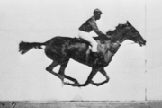 uybridge, yep the spelling is correct, settled a bet on whether the hoofs of a horse galloping are ever all in the air at once. Wagers aside, collaborating with John D. Isaacs, the resultant photographic apparatus ushered in the very start of that Leviathan we've all come to love, motion pictures. [Here's a great link to his work from a really good online Gallery; Artsy. Well worth a look]
 uybridge, yep the spelling is correct, settled a bet on whether the hoofs of a horse galloping are ever all in the air at once. Wagers aside, collaborating with John D. Isaacs, the resultant photographic apparatus ushered in the very start of that Leviathan we've all come to love, motion pictures. [Here's a great link to his work from a really good online Gallery; Artsy. Well worth a look]